OpenStreetMap logo OpenStreetMap

Users' Diaries

Recent diary entries

My name is Victor, a 300-level student of the Geography and Environmental Management Department, University of Port Harcourt.

I am very excited to announce that I have joined the Unique Mappers IT Internship program.

This opportunity aligns perfectly with my love for technology and my desire to gain hands-on experience in the field of geographic information systems (GIS) and mapping technologies.

The Unique Mappers Network Nigeria is a renowned organization due to its approach and commitment to community-driven projects, making it an ideal platform for me to enhance my skills and contribute meaningfully.

I am also excited to work with a team of talented professionals and colleagues, learning from them and sharing my ideas.

Joining the Unique Mappers IT Internship is a significant step in my career journey, and I am ready to embrace the challenges and opportunities along the way.

I started my industrial training IT internship at Unique Mappers Network, Nigeria today. I’m excited to learn and contribute to the OpenStreetMap project. So far, I’ve met the team and gotten a brief overview of the company’s goals and objectives. I’m looking forward to learning more about the projects they’re working on and how I can assist.

Goals for the next few days:

  • Get familiar with the company’s workflow and tools
  • Meet with my supervisor to discuss my tasks and objectives
  • Start learning more about OpenStreetMap and how to contribute to it

I’ll update this diary as I progress and learn more. For now, I’m just taking it all in and trying to absorb as much as I can

Today I mapped Gllavë which is a tiny village in Memaliaj.

I wandered around the map to check how this remote tiny village is connected to main streets and I found out there are many tiny villages scattered through the mountain and none of them seem to be connected (or I can not figure out how they are connected) to the main roads.

I continued mapping, and I lost count how many small villages I mapped today. I am attaching the area I mapped and if anybody knows a quick way to figure out if these villages are in any way connected to main streets can let me know in the comments.

“#100villagesin100days #day28”

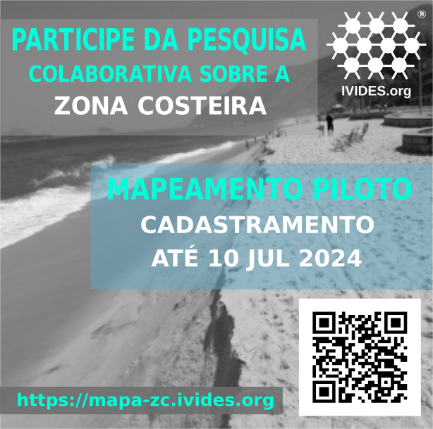
Mapeamento colaborativo com OpenStreetMap será realizado para avaliar aspectos relacionados à sustentabilidade de região estratégica para o país


convite

Este é um projeto promovido pelo Instituto Virtual para o Desenvolvimento Sustentável – IVIDES.org® e integrado à plataforma de iniciativas para alcance dos Objetivos de Desenvolvimento Sustentável (ODS), mantida pelas Nações Unidas.

A iniciativa, denominada Sustainable Brazilian Ocean and Coasts Initiative - Scientific community, OceanAction43529, conta com a participação da população e utiliza apenas software livre.


INSCREVA-SE AQUI para participar do piloto de mapeamento.

A pesquisa objetiva disponibilizar uma plataforma colaborativa para mapeamento de aspectos positivos e negativos das zonas costeira e marinha do Brasil, utilizando a base cartográfica digital OpenStreetMap.

Na primeira fase da pesquisa, em 2023, foi realizada uma consulta pública, a respeito de dois conjuntos de ícones para mapeamento, sobre a sua capacidade de comunicar o aspecto a ser representado.

Na segunda fase, 2024, está programada a realização de um mapeamento piloto, para teste da plataforma. Para tanto, foi disponibilizado um formulário eletrônico, desenvolvido com Enketo KoboToolbox, para inscrição dos(as) interessados(as), até 15 de julho de 2024, 23:59 (UTC).


INSCREVA-SE AQUI para participar do piloto de mapeamento.

Entre as feições a serem mapeadas, estão, por exemplo: (i) positivamente: posto de reciclagem, área marinha protegida (ou outras unidades de conservação), ponto para disposição adequada de lixo, posto de salva-mar, posto de informações para o turista etc; (ii) negativamente, os locais de ocorrência de derrame de petróleo (ou outros resíduos perigosos), de pesca ilegal, de despejo de esgoto in natura no ambiente, de extração ilegal de areia (ou outros minerais) etc.

A Dra. Raquel Dezidério Souto (IVIDES.org e UFRJ), coordenadora da pesquisa e responsável pelo desenvolvimento do sistema, salienta que a iniciativa tem por objetivo, avaliar a aplicabilidade do mapeamento colaborativo aberto, na inferência sobre o estado das zonas costeira e marinha, contando com VGI (volunteered geographic information).

O desenvolvimento de metodologia para ajudar a promover a sustentabilidade desta importante região é uma das etapas finais do estágio pós-doutoral, que a pesquisadora realiza há cinco anos, junto ao Programa de Pós-graduação em Geografia, da Universidade Federal do Rio de Janeiro (PPGG-UFRJ).

IVIDES.org® é uma marca registrada.


IVIDES_logo

Finally! After over four months of near-daily almost painstaking manual editing work in JOSM, entirely using aerial imagery with no automated imports whatsoever, and going through a few episodes of arm and hand cramping, all of the remaining woodland data on Vancouver Island, all the way northwest to Cape Scott, is now present in OpenStreetMap. I hope I was able to depict my own part of the world here just a bit prettier than before.

Location: 49.663, -125.747

Este é o quarto entre os diários de campo que compõem o caderno de campo da minha pesquisa sobre interações sociotécnicas nos Altos e Córregos da Zona Norte do Recife e sua área contígua em Olinda, cidades localizadas na Região Metropolitana do Recife (RMR). Mais detalhes sobre a pesquisa vocês podem ver na minha tese de doutorado, publicada em https://repositorio.ufpe.br/handle/123456789/48802. Para a tese a delimitação socioespacial foram os Altos e Córregos da Zona Norte do Recife, a parte de Olinda foi agregada depois da tese.

Os diários de campo foram realizados em minhas idas ao território objeto de estudo. Nessas idas sempre registrei o percurso com o aplicativo OSM Tracker. Esse diário diz repeito a ida para a sede da EScola Pernambucana de Circo, no Alto do Burity, Recife/PE http://u.osmfr.org/m/757844/ .

alt=track do percurso realizado neste campo

Segue abaixo o diário de campo na íntegra, apenas com alterações de nomes pessoais, com o intuito de resguardar a identidade das interlocutoras:

A principal motivação para ter ido ao Alto do Burity, no bairro da Macaxeira, foi a de entrevistar um representante da Escola Pernambucana de Circo, um ponto de cultura com alta incidência nas ações sociais nos morros da zona norte do Recife. A escola fica em uma avenida transversal à Avenida Norte, a Avenida José Américo de Almeida, onde há de um lado, o mesmo da Escola Pernambucana de Circo diversos comércios, como mercadinhos, pet shops, quitandas, lava jato e no lado oposto alguns prédios “caixão” que formam os conjuntos residenciais: Aquarela, Matias Cardoso de Almeida, Apipucos e Cidade Recife. A avenida segue ladeirada subindo para a parte efetivamente alta do Burity e segue até o limite com o Córrego da Areia.

alt=Fachada da Escola Pernambucana de Circo

Enquanto o meu interlocutor, o coordenador pedagógico da Escola, não chegava, o esperei num grande salão central na sede do ponto de cultura, equipado com equipamentos para impulsionar saltos, testar equilíbrio em fios e tecidos e um grupo de oito pessoas ensaiava, fazendo exercícios físicos inerentes as atividades citadas. Depois, durante a entrevista, ele me falou que aquele grupo é uma trupe, a Trupe Circus, que é o grupo que se apresenta em nome da Escola na sede e em outros locais também, formado por ex-alunos dos cursos promovidos por lá. Eles ensaiam diariamente pela manhã, enquanto à tarde, o espaço é ocupado pelos alunos iniciantes, formado por crianças e adolescentes que aprendem as primeiras habilidades para atuar nas artes circenses.

alt=Foto do salao de treino onde tambem sao realizados os espetaculos

Fui recebido no escritório, na parte superior do prédio. Chegando lá, meu locutor passou cerca de 45 minutos conversando sobre a conjuntura política do país. Depois desse tempo, enfim, começamos a entrevista, ainda com respostas muito longas por parte dele, de maneira que precisamos remarcar pra continuar a entrevista em outro momento, pois o mesmo tinha um compromisso cujo horário se aproximava. Pedi então para fazer algumas fotos e vi que lá da sala em que estávamos há uma vista privilegiada dos morros, ao pedir autorização pra ele pra fazer uma foto, ele me indicou o topo do prédio, que é acessado por uma escada e de fato propicia uma visão deslumbrante dos morros que ficam na confluência entre os bairros da Macaxeira e Nova Descoberta.

alt=Vista da escada no topo da sede da escola pernambucana de circo 1

Depois ele me mostrou as outras instalações do espaço que são compostas de salas para armazenamento de material (pernas de pau, bolas de equilíbrio, acessórios de palhaço, bambolê, instrumentos, material de cenário, etc). No salão ainda é possível identificar uma arquibancada que, segundo o meu interlocutor é reforçado por cadeiras ao redor do salão, podendo receber até 150 pessoas e chama a atenção o teto, com várias estruturas para se equilibrar. Ao final, ficamos de marcar outro momento para completarmos a entrevista e segui rumo a Avenida Norte para tomar o caminho de volta.

alt=Aparelho para treinar equilibrio na corda

alt=bamboles - bicicletas de uma roda soh - pinos para acrobacias 2

alt=Bolas de equilibrio circense

alt=Equipamentos da parte alta

alt=Sapastos de palhaco no deposito

alt=Tecido para treinar equilibrio no alto de vermelho

alt=Arquibancadas para acomodar o publico com pula pula profissional ao fundo

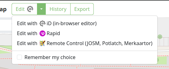
I made a Chrome extension (which should be compatible with all Chromium-based browsers) and Firefox Add-on that hooks into the osm.org Edit buttons and redirects it to Rapid. Also, it integrates Strava heatmap support into Rapid as overlay imagery.

It’s an early version, and I’m sure there’s bugs, so please open issues (suggestions welcome too): https://github.com/emersonveenstra/rapid-power-user-extension/issues

Also, for those wondering, I am jumping back into osmdiscussiontracker development soon, I just needed to scratch this itch first :)

Happy mapping!

EDIT THE CONSENCOUS HAS NOW CHANGED TO SAY THAT THIS DATA IS REMOVED BECAUSE OF A UNDOCUMENTED IMPORT WHICH IS EXACTLY THE REASON I SAID IT SHOULD HAVE BEEN REMOVED UNDER NOT BECAUSE OF A COPYRIGHT VIOLATION

context https://community.openstreetmap.org/t/apparent-use-of-unauthorised-source-for-beach-names-in-australia/108721

The names of our beaches is open and public data in Australia, the names of our beaches have been deleted for no reason at all.

this removal was based on a unofficial chat room discussion which is not documented for anybody to see.

the surf life saving club does not own the right to the names of our beaches, however granted the the surf life saving club may not the the most direct source of this information. but we have a full waiver to use this information none-the-less from our government.

there was never a formal proposal about the removal of this information

along with this massive deletion was other information such as boat ramps and beaches drawn in clearly by using imagery.

posting here because my comments keep getting removed by the moderators now.

Welcome to the thirteenth OpenStreetMap NextGen development diary.

🔖 You can read other development diaries here:
https://www.openstreetmap.org/user/NorthCrab/diary/

⭐ This project is open-source — join us today!
https://github.com/Zaczero/openstreetmap-ng

🛈 This initiative is not affiliated with the OpenStreetMap Foundation.

In case you missed it…

Last week, we showcased Search 2.0: a comprehensive overhaul of the search functionality. For the first time, OSM search is now simple and intuitive to use. It’s a must-see (there’s a video too)!

Default Editor Switching

This week, OpenStreetMap-NG introduced a convenient way to change your default editor. By exposing this functionality, previously hidden in settings, we prevent editor lock-in and allow users to easily experiment with other editors. A small icon now indicates which editor is currently set as default.

Faster and Slimmer GPX Traces

We completed a major overhaul of the GPX trace database design. Here are the results:

  • Storing traces is now much more efficient, with an 80% reduction in data size. What previously required 1TB of storage now only needs less than 200GB.
  • Uploading and downloading traces is noticeably faster.
  • There is no performance impact on querying individual tracepoints.

While further storage reduction is possible, it would slightly degrade the performance of querying individual tracepoints. Given the substantial 80% reduction already achieved, we decided not to pursue further optimization at this time.

Refreshed Data Alerts UI

We recently migrated and refreshed the map data alerts. Below are side-by-side comparisons with brief commentary.

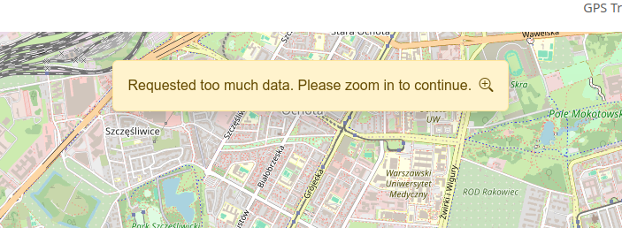
When loading a large amount of data, users are now presented with a much simpler message and a clear decision: show the data or hide it? The previous message included unnecessary details and a small grammatical mistake (“Are sure you”). The (X) button was also unintuitive, making its function unclear.

When deciding to load even more data, the server may silently abort the request. Previously, users were left without any indication of what was happening. With OpenStreetMap-NG, users now see a new alert with instructions on what to do next.

Let’s wrap up this week’s highlights with something visually pleasing. We now have a new logo, which will be used for the project’s and soon the organization’s branding.

And here’s how it looks in the project’s README:

Sponsors

This week’s work was sponsored by 15 people!
8 donors on Liberapay, and 7 on GitHub Sponsors.

Your support makes all the difference! 🔥

Please consider supporting the OpenStreetMap-NG development with any amount. As a thank you, you will be eligible for the unique OpenStreetMap-NG Founder profile badge. You will also help to push the project forward 🏋.

Hi! This is Faiza Waziha. One of the Gurus of the Open Mapping Guru Fellowship. This journey started when I was selected to be a part of this incredible journey in 2023.

First of all, I want to mention the vibes this community gives. It is very welcoming, energetic and inspiring. I love the enthusiasm so much!! This is one of the reasons I get to learn so much from them and to communicate with them without worries.

There were 3 tracks in the fellowship (Training, Mapping, and Validation). I was part of the Mapping track. After getting the briefing about what we will be doing for the next 5 months, I was pumped up for the challenges. We got to map various countries; India, Bangladesh and also some Island countries like Tonga, Vanuatu, and Micronesia. Which were very interesting and got learned many geological characteristics of those areas.

From this fellowship, I have learned to use Josm (It is the most efficient thing a mapper can have to map anything and I love it!!), Mappilary and Everydoor. Also the use of Josm in validation, how to use the open data source for data analysis in QGIS. These skills will help me in building my career as a GIS analyst.

This fellowship allowed me to connect and communicate with many talented individuals like Brazil Singh Rittik Vai, Khan Mohammed Ibtehal Vai, Can Unen and many more. It was also a great experience to be a part of Slum area mapping in Mirpur in collaboration with World Vision Bangladesh. I get to lead an amazing team- Sozin’s Comet in the Climate Change Challenge 2024. Though we didn’t win any prizes it has helped me a lot in how to manage a team, how to stay motivated and keep others motivated. I learned that communication is the key to leadership. I have grown as a mapper and also a better human being.

Lastly, I want to thank Mikko Tamura, and Honey Fombuena for their immense support and for pushing us to reach our goals. Thank you so much!!

Location: 23.824, 90.353

Sometimes I think I’m a bottom feeder going through the map and cleaning up the obvious errors and this comes from my observations over time and cleaning up thousands of duplicate buildings.

Because many countries do not have good census data you can do a rough calculation by multiplying the number of houses by an average number of people who live in them. It isn’t perfect but if you have nothing better then it works.

So duplicate buildings are a problem. When you’re looking to see how many schools you need duplicate buildings mess the numbers up. Buildings incorrectly tagged or not tagged at all also mess the numbers up.

Then we get to the imagery used. These days I’m seeing more and more microsoft BuildingFootprints tags on buildings. They are normally very accurate and align well with Bing imagery. The largest most accurate satellites are only accurate to 60 meters so the imagery has to be aligned. My recommendation would be to use Bing imagery and find a building that aligns with it. Then switch to your preferred imagery and align it with the Bing aligned one.

This helps ensure that buildings are only mapped once and when you add buildings you don’t add an existing building and if someone imports using microsoft BuildingFootprints then your building won’t be remapped 10 meters away in the future.

Disposable mappers are often used meaning many will only may a few times. So we don’t really have time to train them.

We want to get the most accurate mapping we can from them and as many buildings as we can. With JOSM buildings_tool plugin I can highlight one building then add more by clicking and holding down the button, moving to the opposite corner of the building and releasing the mouse button. If they aren’t in line it takes another mouse button click. You get a rectangular building correctly labelled. This is far less than using iD. Plus you don’t need a validator to inspect each one to see if it is correct.

You need to install JOSM and Microsoft openJDK but you’ll get a lot more buildings out of them. It is possible to set it all up on a USB stick and run it from there.

With iD mapped buildings there is room for error in tagging. Some aren’t tagged at all, I’ve seen some tagged barrier=fence amongst others. Also many buildings are rectangular in shape but you won’t think it from the mapping.

The buildings tagged microsoft BuildingFootprints implies an import. Officially there is a formal process for an import. If you are importing please follow it. Part of the requirement is to visually check to see if the building has already been mapped. I strongly suspect this is not being followed in all cases.

Thanks for reading

John

Posted by Pisto81 on 30 June 2024 in English.

Well, the fellowship was the first of its kind for me. The whole time, the commitment led me to learn and know the vast features and tools of OpenStreetMap. The fact that overwhelmed me most that how the organization has managed and engaged numerous volunteers and improved its tools over time. Training and resources were efficient and convenient in a structure that proved instrumental for me in completing the tasks. The biggest delight is seeing my edits come into visualization within moments which truly instills a feeling that I am making an impact by mapping. Throughout the whole time, I have been able to discover a little of it and may also have made slight and/or big mistakes during edits or validation, ahead of this, I want to explore this platform more and be an instrumental mapper.