Trail Ridge Road: The US' awe-inspiring 'Highway to the Sky'

 Getty Images
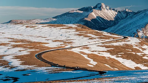
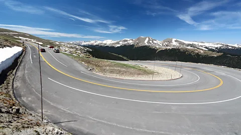
Snaking for 48 miles through Rocky Mountain National Park, Trail Ridge Road traverses some of Colorado's wildest country in a series of hair-raising twists and turns.
I stood at the Gore Range Overlook, gazing at the snow-capped and barren Never Summer Mountains to the west surrounded by fragile and beautiful alpine tundra below. At 12,048ft in elevation, this is one of the highest stops along Trail Ridge Road, an epic byway that runs through Colorado's Rocky Mountain National Park (RMNP).
Nicknamed the "Highway to the Sky", the 48-mile route traverses some of Colorado's wildest country in a series of hair-raising twists and turns with no guardrail, crossing the Continental Divide and soaring over the park's dramatic tundra. It's the highest continuously paved road in the United States and a hugely impressive feat of engineering. Gore Range Overlook isn't just a place to stop after a white-knuckle drive; it's a place to experience some of the best views in the entire park.
Since 95% of Rocky Mountain National Park is designated wilderness that's only accessible to adventurous hikers, Trail Ridge Road is one of the most popular ways to explore the area. Driving it as the road twists through trees along switchbacks and hairpin turns reveals vistas of vast meadows, stretches of road densely lined with towering evergreen trees, dramatic mountain ranges scraping the sky, fields of alpine tundra and rocky drop-offs on the dramatic 4,000ft climb from the town of Estes Park on the park's east side to Grand Lake on the west.
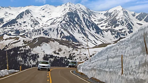
Snow-covered for most of the year, Trail Ridge Road is only passable between June and September. While the drive is intimidating to some, clearing the road of snow each year is even more daunting.
"We take great pride in working to get this historic road open," says Michael Bernhardt, RMNP roads and fleet supervisor. "Removing snow while being isolated from society for six weeks is a transformative experience. Our crews battle gale force winds, white-out conditions, sheer drop offs, snow drifts and ice that exceed 20ft in depth. There are some days where you can't see the front of your machine due to poor weather conditions with a several hundred foot drop-off just inches or feet away."
 Peter Baker/NPS
Just as clearing Trail Ridge Road is no small feat, building it was just as complicated. RMNP is one of the county's oldest national parks, established in 1915 just before automobile ownership became mainstream.
Driving Trail Ridge Road
Visitors to Trail Ridge Road should make timed reservations. While the drive can be made in just a couple of hours, most people recommend planning a day. Be prepared for rapid and dramatic weather and temperature changes.
If you want to let someone else take the wheel, Rocky Mountain Conservancy offers two bus tours for a fee, the Trail Ridge Road Scenic Ecology Tour and the Journey Over the Divide Scenic Ecology Tour. Both offer in-depth explorations of the park's flora and fauna along several stops with photo ops and a picnic lunch.
By the late 1920s, more visitors wanted to explore by car, but the original thoroughfare, Fall River Road (which remains an unpaved driving trail today), was too narrow for the increasing traffic. Fall River Road's 11-mile route has one lane, no guard rails, a 16% grade (compared to Trail Ridge Road's 7%), many switchbacks and a 15mph speed limit. Avalanches, deep snowbanks and limited viewpoints were problematic. Trail Ridge Road was built to accommodate more visitors – but was also an innovative way to put young men to work at the height of the Great Depression.
Trail Ridge Road was partly a project of the Civilian Conservation Corps (CCC), a programme created to employ men ages 18-25 to combat the country's economic downturn and improve the US' forests, parks and public lands. Among many things, the CCC planted billions of trees and constructed 126,000 miles of roads and trails – one of which was Trail Ridge Road.
 Getty Images
Starting in 1929, workers only had about four months of the year (mid-June to mid-October, roughly when the road is open to drivers today) to dig, excavate and pave the road. Among the challenges they faced were dramatically changing weather conditions and permafrost that could cause permanent quagmires. They needed to blast through rock, remove massive logs and construct structures to prevent erosion, while blending the road in with the park's natural landscape. At peak construction, 150 workers used horses, a steam shovel, tractors and graders. Trail Ridge Road was completed in 1932 and extended to Grand Lake by 1938. The first year it was open, 250,000 people visited the park by car and bus. Today, Rocky Mountain National Park sees more than 4.5 million annual visitors, and Trail Ridge Road is one of the park's most popular destinations.
The road's history stretches back long before the 1930s, though. The route follows pathways created in prehistoric times by the Ute people, the Indigenous tribes that lived (and still live) in present-day Colorado and Utah, who used it for hunting and gathering food during the summer. Archaeologists have discovered game drives – strategically placed rocks to trap animals – along with wickiups, conical dwellings made of juniper branches, in the area.
More like this:
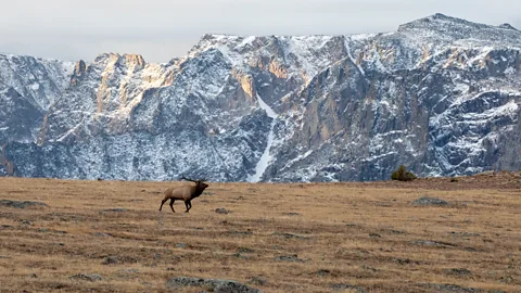
When I drove the route on a brisk autumn day, the leaves on the aspen trees were starting their annual shift from verdant green to brilliant gold and orange, tiny colourful wildflowers dotted the landscape, and the silhouettes of mountain peaks faded into the distance. I drove through lush forests, alpine meadows, clifflike rock formations and outcroppings. Every stop seemed to include an encounter with local wildlife: majestic elk and moose, skittering chipmunks and fluffy marmots abounded.
 Ann Schonlau/NPS
Once I passed the tree line, I stopped to explore the delicate and unique tundra ecosystem on a short hike at the Forest Canyon Overlook trail. At Rock Cut, a roadside stop where you can see how workers removed rock to create Trail Ridge Road, I followed the one-mile hike across the barren landscape, and saw marmots, pika and elk.
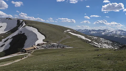
The Alpine Visitor Center offers a ranger-guided Tundra Nature Walk where you'll learn about the alpine ecosystem, the extreme weather and the region's ancient geology. (Free; offered most days from mid-June to mid-August).
About halfway through the drive, just past cliffs formed by volcanic ash (aptly called Lava Cliffs), I drove over the highest point of the trek—a whopping 12,183ft – just before reaching the Alpine Visitor Center, which is full of interactive educational exhibits about the plants and animals of the area and how the road was built.
"We've got great exhibits at the Alpine Visitor Center that highlight some of the plants that call the alpine tundra home and what their root system is like, some information about wildflowers that might only bloom every decade," says Kyle Patterson, Management Specialist/Public Affairs Officer at Rocky Mountain National Park.
A few miles past the Alpine Visitor Center, Milner Pass is where the Continental Divide crosses the peaks, dividing water that will flow towards the Atlantic or the Pacific. After a series of numbered switchbacks with stops along the way to hike and view wildlife, you'll reach the Holzwarth Historic Site, a 1900s-era homestead built by a plucky family of German immigrants who thrived despite the challenges of high country life, building a sawmill, cutting ice from Grand Lake to sell for refrigeration and eventually creating the area's first guest ranch. Near the end of the road and the town of Grand Lake, the Coyote Valley Trailhead offered me a peaceful place to stroll and stretch my legs.
 Getty Images
"You just fall in love with this ecosystem because you realise how special it is and how special it is to experience it and how much we need to take care of it," Patterson said. "It's so fun to be there with somebody who has never experienced anything like Trail Ridge Road before and to see it through their eyes and realise what an amazing feature of the park it is."
The Open Road is a celebration of the world's most remarkable highways and byways, and a reminder that some of the greatest travel adventures happen via wheels.
--
If you liked this story, sign up for The Essential List newsletter – a handpicked selection of features, videos and can't-miss news, delivered to your inbox twice a week.